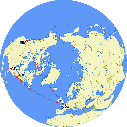
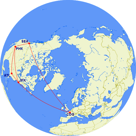
Kathryn and I have recently been booking flights for trips to Europe. As our gateway tends to be Paris, we’ve grown accustomed to certain routes between here and there. More often than not, our travel plans take us through Atlanta, although Salt Lake City, Detroit, and Minneapolis have occasionally been stopovers as well.
Recently, though, routes have started appearing through other airports on this side of the Atlantic. Seeing New York on the list wasn’t too much of a surprise. However, seeing Seattle as a stopover between Phoenix and Paris caught us a bit off-guard. Why would one fly so far west only to head east again? Curiously, some of the routes passing through Seattle have had relatively short total travel times.
At issue, I think, is the fact that we often get our minds trained to think about places as they appear on paper maps — or at least as they appear on maps on computer screens. Maps are an attempt to project a round world onto a flat surface. For short distances, most projections offer a good approximation. However, for longer distances, where the curvature of the earth comes into play, most do not. The east-west-north-south paradigm tends to become somewhat meaningless as distances increase.
To get a better understanding of the distances involved on these different routes, I used Karl L. Swartz’s excellent Great Circle Mapper website, which has been around since before most people knew what a website was. The results were enlightening.
First, Seattle isn’t much farther from Paris than New York or Atlanta are. Farther, for sure, but not as much as one might think.

| From | To | Distance |
| CDG | JFK | 3,635 mi |
| CDG | ATL | 4,394 mi |
| CDG | SEA | 5,016 mi |
Although Seattle is 2,421 mi from New York, Seattle is only 1,381 miles farther from Paris than New York is.
However, for Kathryn and me, these distances are just intermediate segments. We want to get between Phoenix and Paris. And while Seattle may be farther from Paris, it’s considerably closer to Phoenix than either New York or Atlanta.
| From | To | Distance |
| PHX | JFK | 2,153 mi |
| PHX | ATL | 1,587 mi |
| PHX | SEA | 1,107 mi |
Putting it all together, we see that a route from Phoenix to Paris with a stopover in Seattle isn’t substantially longer than one with a stopover in Atlanta or New York.

| Route | Distance |
| PHX-JFK-CDG | 5,788 mi |
| PHX-ATL-CDG | 5,982 mi |
| PHX-SEA-CDG | 6,123 mi |
In the end, it turns out there’s only 335 miles of difference from the longest to the shortest of these three routes. It means, in most cases, the best route will be the one with the best connections, give or take perhaps at most an hour.
Interesting on the distances involved (and how similar they are). The actual maps came through in the email alert. The don’t seem to be in the post, at least on Chrome.
It wasn’t until after I posted that I noticed the maps trigger security warnings in Firefox. I hadn’t checked Chrome, which tends to block “threats” more aggressively. There’s no real threat; it’s just linking to a website that’s been around since before the days of HTTPS.
Well that is interesting. I would have never guessed! SeaTac is a much nicer place to layover than JFK
It’s surprising how little difference going all the way to the opposite coast makes! I’ve only ever had one layover at JFK and it was a total cluster, but mostly because I had to change terminals.